We're excited to announce that Navixy now supports nautical miles. As a result of this new measurement system, we are able to provide a better experience for our global partners and their customers that ship goods by sea.
Whether shipping from city to city or continent to continent, we help companies ensure safe, reliable deliveries. In today's tech-driven world, everything can be tracked and monitored, even ships and boats lost at sea. In addition to tracking vehicles, assets and people, Navixy partners worldwide can also track ships and vessels. As the name implies, a vessel tracking system consists of a set of equipment for tracking, identifying, and monitoring ship locations, and any other details relevant to the maneuvering and stabilizing of ships.
What is a vessel tracking system?
A vessel tracking system is extremely important in today's highly advanced maritime world, providing long range connectivity not just between ships and coast guards of nations, but also between ships themselves. Since the advent of the internet, many of these vessel tracking systems have managed to incorporate internet connectivity into their core objective, thereby providing a much better service. There are a wide variety of vessel tracking systems that are available in the naval vessel market and each has its own unique feasibility; such as vessel monitoring systems (VMS) and automated identification system (AIS).
One of the most common vessel tracking systems is GPS. GPS, as you may already know from Navixy’s offerings in asset monitoring, is much more than just an exact location. Navixy’s GPS asset monitoring, for example, captures and retains real-time data with visibility across platforms, offers user-friendly reports and alerts, geofencing, POI, and much more. This enhances protection for vehicles, cargo and equipment from theft, unauthorized use, etc. Explore more about Navixy’s safety measurements in the transportation and logistics industry here.
Why do we need nautical miles?
The National Oceanic and Atmospheric Administration (NOAA) explains that using latitude and longitude coordinates is more practical for long-distance travel, where the curvature of the Earth becomes a factor in accurate measurement. Nautical charts use latitude and longitude, so it’s far easier for mariners to measure distance in nautical miles. Air and space travel also use latitude and longitude for navigation and nautical miles to measure distance.
Nautical miles are used to measure the distance traveled through water, and are slightly longer than a mile on land, equaling 1.1508 land-measured (or statute) miles. The nautical mile is based on the Earth’s latitude coordinates, with one nautical mile equaling one minute of latitude. Nautical miles are different from knots— knots measure speed and nautical miles measure distance. One knot equals one nautical mile per hour, or roughly 1.15 statute mph.
Navixy for your fleet
Although many ships use vessel tracking systems to monitor and pinpoint their courses, there are several constraints and pain points with certain GPS systems. Distance and speed are measured differently for ships as we mentioned above; additional things like distance limits and satellite transmission problems are some issues that can often hinder the highly beneficial operation of the vessel tracking systems.
This is where Navixy can help. Where you previously tracked and traced vessels on our platform with kilometers, we now offer accurate nautical tracking with correct measurements: nautical miles and marine knots for boats. We offer many other parameters and customizable alerts. Think you may be interested in offering marine tracking but you are unsure where to begin? Contact our support team today to learn what device models are great for boats and vessels.
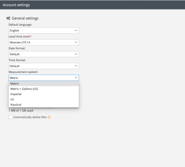
In your account settings, you can now choose the specified measurement system. Nautical will appear. Enjoy your updated settings!
Navixy use cases at sea
Bodo Erken, expert in tracking at Trackerando, our Navixy partner in Germany, spoke with our team about our software in use, in specific regards to our nautical tracking solutions and industry demand. Trackerando specializes in security and tracking 4.0, developed for various levels of asset management with more than ten years' experience as innovators and distributors of tracking solutions. Here’s what Erken said:
“In Germany, Austria and Switzerland, more than 240,000 people own a motor yacht and more than 1 million people own boats. Unlike yachts and larger technologically savvy vessels, many smaller boats don’t have security and navigational systems; this is why so many boat owners are in the market and looking to install smart, reasonably priced solutions to protect their boat. Also, charter companies want a tool to protect and analyze their boats. Trackerando provides unique protection for boats, and with Navixy and Teltonika we are excited to change the market in 2022. Navixy can provide unique features for boaters like knots, nautical miles and an open sea map layer; While Teltonika provides a tracking device with NMEA2000 protocol and BLE sensors.
In 2022, we at Trackerando will offer water sports enthusiasts and charter companies a new way to monitor and protect, utilizng with the benefits of GPS tracking, user-friendliness, and high standards."
Theodor Kabitsis of Alfakom, works with Navixy’s platform for clients using GPS trackers on the Navixy platform for jet skis, rental boats, yachts and essentially all other battery operated mobiles and other forms of sea travel. They also use nautical measurements for all marine companies they work with. He explains the importance and future possibilities of the topic and growing industry:
“Having this feature is a great asset, but also essential since EU law has obligated boats and naval units to print routes to have nautical measurements. In the future, we look forward to expanding in the boats sector and growing substantially not only in Greece, which already has a very large quantity of boats, but in the EU as well."
We spoke with José Gabriel Ferreira, Poseidón Technologies Manager and he explained how nautical mile tracking allows specific arrival time updates with longitude and latitude measuring. Poseidon offers advanced vessel tracking and logistic systems for clients at sea.
"For us at Poseidon, being able to measure in nautical miles and knots is important for two things:
With nautical miles and knots measurements, we can calculate our ships estimated time of arrival at ports. The knots consider the latitude and longitude of the ship between one point and another, thereby estimating the ship's speed at sea. This way we can know how many knots the boat is traveling at and estimate when it will arrive at the port.
Another extremely valuable quality is that the nautical miles tracking saves us money. With a more specific arrival estimation, we won’t overpay for docking and additional services that are deployed for the ships reception and much more. Having an exact time (determined by knots and miles) is critical for the maritime industry."


