Four ways to improve operations with location-based fleet automation

AuthorRoman S, Product owner, Navixy integrations
Your geofences work. They detect boundary crossings, log entries and exits, and send notifications. And then someone has to read that notification, decide if it matters, and figure out what to do about it. The gap between detection and response is where operations lose money.
This article shows you four ready-to-use templates that close that gap automatically.
The operational reality of location-dependent industries
Construction, logistics, oil and gas, municipal fleets, and agriculture all share a fundamental characteristic – location defines what counts as normal. An excavator on a job site at 10 AM is working. The same excavator leaving the site at 2 AM is a problem.
The numbers make this concrete. In the US, over 11,000 construction equipment thefts are reported annually, with the actual figure estimated at two to three times higher. The recovery rate sits below 21%, meaning most stolen equipment is gone for good. In the UK, construction site theft costs the industry more than £1 billion every year.
But theft is only one category of location-dependent risk. Consider unauthorized after-hours use, where equipment accumulates engine hours, fuel consumption, and wear without generating revenue. Consider speed violations in zones where pedestrians work alongside heavy machinery. Consider vehicles entering restricted areas near active drilling operations or flood-prone roads.
These are not monitoring problems. Fleet managers have been using geofences for ages. The challenge is that alerts require human interpretation, manual prioritization, and reactive response. A notification at 3 AM about equipment leaving a site does not stop the equipment from leaving.
How fleet geofencing creates operational context
Geofencing defines the operational boundaries of normal behavior. A delivery zone, a job site perimeter, a restricted area, a designated parking location. Each boundary represents a decision about what should happen where.
Standard geofence alerts tell you when those boundaries get crossed. Entry, exit, dwell time. This information is valuable. It creates an operational record and enables analysis.
The limitation is structural. An alert is information, not action. It requires someone to receive it, assess it, and decide what to do. During business hours, that might work. During off-hours, weekends, or high-volume periods where dozens of alerts compete for attention, the detection-to-response gap expands.
Geofencing gets you halfway there. The question is what happens after the boundary crossing.
Geofencing automation with IoT Logic
IoT Logic is Navixy's no-code automation tool that lets you build rules connecting telematics events to device commands, notifications, and external systems. The recent addition of geozones as parameters means location context now flows directly into automation logic.
The mechanism works like this: a location event (entry, exit, position inside a zone) triggers a condition check. If the conditions match, the system executes actions automatically. Those actions can include activating device outputs (buzzers, immobilizers), sending webhook notifications to external systems, and logging events to the tracking record.
This shifts the operational model. Instead of "detect, alert, wait for human response," the sequence becomes "detect, evaluate conditions, execute response." The four templates below implement this pattern for the most common location-dependent challenges.
Template 1: Zone speed limit
The zone speed limit template addresses a specific problem: enforcing different speed rules inside defined areas. A 60 km/h limit on public roads might be safe, but the same speed in a loading zone with pedestrians or through a residential delivery area creates liability.
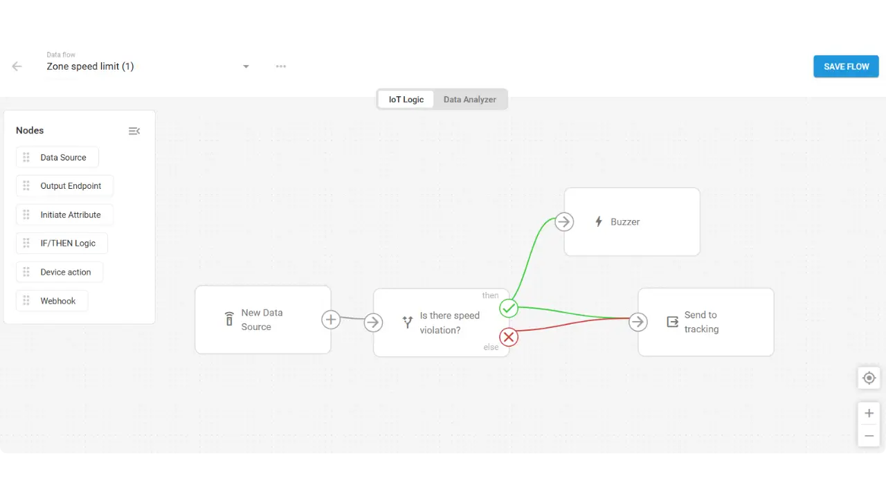
The template uses continuous condition checking. It monitors whether the vehicle is inside the designated geofence AND whether speed exceeds the threshold. Both conditions must be true. When they are, two things happen simultaneously: the device triggers output 1 (typically a buzzer), giving the driver immediate feedback, and the event gets logged to the tracking record.
In mining and heavy industry, this enforces speed limits in loading zones and personnel areas where visibility is limited and stopping distances matter. In logistics and last-mile delivery, it provides compliance documentation for residential delivery areas where customers and pedestrians share the space.
The template is configurable. The speed threshold, the target geofence, and the output action can all be adjusted for specific operational requirements.
Template 2: Parking off-site after hours
This template combines location and time awareness to address two related problems: theft prevention and unauthorized personal use of company assets.
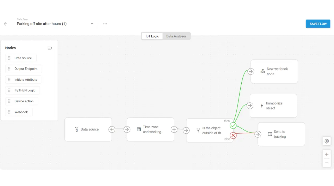
The logic incorporates timezone and working hours. The default configuration uses 9:00 to 21:00 working hours in UTC+2, but these parameters are adjustable. The template then checks a compound condition: is the vehicle outside the designated parking geofence AND is the current time outside working hours OR on a weekend?
When both conditions match, the response is dual. First, a webhook notification goes to the configured endpoint. The template includes Telegram integration as an example, but any webhook-compatible system works. Second, output 2 activates, typically connected to an immobilizer.
For construction operations, this means machinery cannot leave the site during overnight or weekend hours without triggering both an alert and a protective response. For car rental or corporate fleet operations, it enforces authorized parking locations during non-business hours.
This is the most complex template logically, but the no-code interface handles the time calculations and condition combinations without requiring scripting.
Template 3: Dangerous area detection
Some zones require immediate notification at the moment of entry, not continuous monitoring afterward. Restricted areas in oil and gas operations, flood-prone roads, active construction zones where conditions change rapidly.
The dangerous area detection template uses an entry event trigger rather than continuous monitoring. The enterGeofence() function fires once at the moment the boundary is crossed, not repeatedly while the vehicle remains inside.
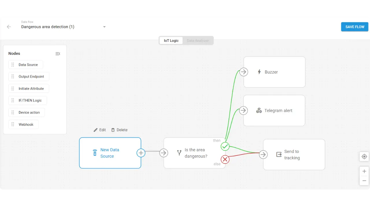
When entry occurs, the template executes three actions in parallel: output 1 activates (buzzer) to alert the driver immediately, a webhook notification goes to supervisors or safety officers, and the event gets logged to tracking. The parallel execution means no sequencing delays. Driver and supervisor learn about the boundary crossing at the same time.
In oil and gas operations, this provides instant alerts when vehicles approach restricted zones near active drilling or processing equipment. In municipal and smart city applications, it can alert when vehicles enter roads closed due to flooding, accidents, or emergency conditions.
The entry event approach avoids alert noise. The system fires once at crossing, not continuously while the vehicle operates legitimately inside a permitted zone.
Template 4: Anti-theft protection
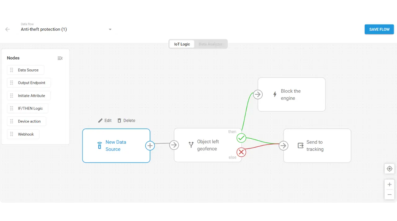
With equipment recovery rates below 21%, prevention matters more than tracking after the fact. The anti-theft template takes a direct approach: when an asset leaves a permitted zone, stop it.
The template uses an exit event trigger. The leaveGeofence()Italic function fires at the moment the vehicle crosses out of the authorized area. The action is immediate: output 2 activates, engaging the immobilizer.
Here’s a critical implementation note. For vehicles that might be in motion at the moment of exit, the template should be paired with devices that support gradual engine cut-off. Teltonika FMB series with SECO (Safe Engine Cut Off) is one example. This prevents sudden stops that could cause accidents while still ensuring the vehicle cannot continue far beyond the boundary.
For automotive dealerships, this stops unauthorized vehicle removal before the vehicle can get far from the lot. For agricultural operations where high-value equipment operates in remote fields with limited physical security, it provides an automated protective response that does not depend on someone monitoring alerts.
Both the exit event and normal data flow go to tracking, ensuring a complete record regardless of whether the theft condition triggered.
Location-based fleet automation beyond basic alerts
So, here’s what we have. Geofencing establishes what normal looks like. Automation delivers the response when boundaries get crossed. The templates remove the human interpretation and manual action steps that create response delays.
For fleet operators, this means protection that does not depend on someone watching alerts. The templates address the most common location-dependent problems, from speed compliance to theft prevention, without requiring custom development or technical resources.
For TSPs building service offerings, location-based automation represents a differentiator you can package for specific verticals. Construction customers, rental companies, oil and gas operators, and municipal fleets all have location-dependent requirements. Low-code telematics automation lets you build solutions tailored to their operations without starting from scratch each time.
The templates are starting points. Customize thresholds, zones, actions, and notification endpoints for specific operational needs. Explore IoT Logic templates and start building location-based automations for your fleet.
Book a demo to see how these geofencing automation templates can work for your operations, or tell us what kind of workflow you want to automate and we’ll help you design it.